
An Epic Cross-Country Trip
- Jul 30, 2025
- 28 min read
[Notes: items with a yellow highlights are links to hotels, parks, restaurants; other items are just in bold to provide a quick guide to the route we traveled; mileage each day is highlighted in green]
In late May 2024, we found ourselves at a point in our lives when we had few obligations keeping us home, so we decided to take an open-ended trip across the United States, with the goal of seeing our children on the west coast, visiting some artists we knew, and hopefully finding inspirational places to paint and write along the way. It was the kind of experience one might expect to be “life-changing.” We weren’t sure the effect would be that dramatic, but we knew for sure that it would force us out of our routines and out of our “comfort zones,” and so might offer us the opportunity for growth and possibly change. James had been wanting to do more plein air painting and had just constructed his own plein air easel and was ready to try it out. So, our trip was partially guided by the fact that he wanted to find sights for painting.

We didn’t have a strict itinerary for the drive. We knew we needed to get to Los Angeles by June 7th because we had an Air BnB reservation we could not adjust or cancel. Beyond that, we did not make any plans for specific accommodations. We knew some places we wanted to stop, but that was it (see my later note about smart phones).
We left New Jersey at 6:45 am on Monday May 27th. It was Memorial Day, so we were concerned about hitting traffic. We took Interstate 80 across all of Pennsylvania. I had read about other possible routes as alternatives to the truck-filled 80. But, we decided to take the most expeditious route. We had a lot of ground to cover! We stopped for a break at Simon B. Elliot State Park in Penfield PA at 11:45 am. It’s a simple state park, with not much in the way of services beyond pit toilets, but it was not crowded at all and had a quiet place to park and take a little rest in the car.
We didn’t know how long we’d drive that first day. We had said that we’d quit driving if we hit any holiday weekend traffic, but it was clear sailing the entire way across Pennsylvania. Once we entered Ohio, we took I76 and US 30 and stopped for the night in Wooster, Ohio. We were glad we made it farther than we had planned; it would give us some flexibility in the coming days.
Wooster is a pleasant town, with quite a few hotels and restaurants, all seemingly doing well (although most were closed on Memorial Day). The town seems to get the economic benefit of having a college nearby (Wooster College) and being the county seat for Wayne County Ohio. It also is home to the Wooster Brush Company and several other large companies. It is surrounded by wide open spaces of farmland. We stayed that night in the Best Western Plus Wooster, which was very nice. After an 8+ hour day on the road, and 504 miles traveled, we called it a night.
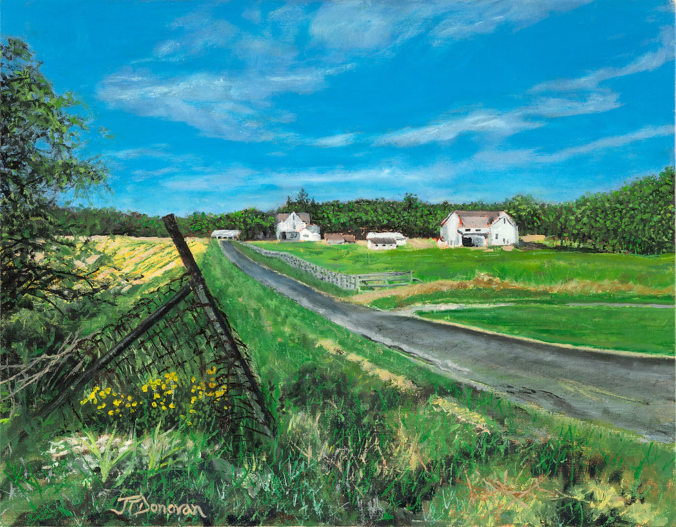
The next morning, Tuesday May 28th, our first morning fully on the road, we took the time to look at maps and see where we might want to go that day, always keeping in mind the goal of heading westward, while also looking for places that would be possible sights for James to paint. Looking at the map that first morning, we saw that nearby was a spring, the Big Prairie Natural Spring, and because we had already realized at this early point that we should have brought more water along, we decided to start our day by heading there.
As we drove through that section of eastern Ohio, mostly on state roads, the green rolling landscape was stunning. The Spring sat at a crossroads, with a cemetery rising on a hill on one side, a small park surrounding the spring on another side, and vast fields of very early corn making up the other two sides. As we took some bottles from the car to fill at the Spring, James noticed a picturesque farmhouse in the distance, and how, with a beautiful patch of flowers in the foreground, it would make for a perfect first plein air painting. So, after we put the water bottles into our cooler (we wished we had brought more empty bottles!), he began the process of setting up his plein air easel and supplies.
It was a really peaceful place to spend some time. They had a little park surrounding the well, with shady places where I could sit and read and plan next steps.
I saw Mohican State Park on maps, with a scenic view of the Mohican Gorge, and another scenic view spot that looked like a good spot to stop and have lunch. So, once James felt he had painted enough and had packed up his things (he got really good at that and could do it in just a few minutes), we headed to the Gorge, where we ate a lunch we had picked up at a local Amish market and then walked the short trail near the Gorge. The view was very obscured by trees, but we were able to get a sense of its vast depth. After that we drove to a picturesque covered bridge spanning the Mohican River. It had clearly been modernized over its history, but it was charming nonetheless. After the bridge, we drove straight through on Route 30 (a stop for gas in Van Wert Ohio) until we entered Indiana. We were struck by the number of wind farms in western Ohio. Seeing the large array of windmills led me to look up exactly what wind farm we were passing and what its history was (another great use of the smart phone!). We learned that this farm we were passing is one of the country’s largest and it was not without controversy. Many local residents were against its construction, and when I looked up their chief complaints, I learned that many were concerned about noise. So, we pulled off on to a little road that led away from the highway, and James stopped the car at a little turnout near one of the windmills. We got out of the car and stood silently. We barely heard a sound from the windmill! I am not sure if they’re all like this, but noise does not seem to be an issue. There were hundreds of them all around us, and not a sound except a gentle “whooshing.”
Once in Indiana, we stopped for the night in New Haven just outside of Fort Wayne Indiana. That night we stayed in a Holiday Inn Express, the only one on our trip, and it was just okay. Therefore, I am not including a link.
We unloaded only what we needed from the car (even after just a couple days on the road we had a very good routine of knowing what needed to be carried in each night), and that night, James brought in his entire plein-aire setup with the intention of continuing to work on his painting that evening. Across from the hotel was Mi Pueblo , a lovely little place with vibrant, colorful art on all of the walls. Even the charming booths were obviously hand-painted. After dinner, James was able to get a couple of hours of painting in before calling it a night. We had covered another 197 miles that day, not that much, but enough to get us where we needed to be tomorrow.
The next morning, Wednesday May 29th, we wanted to make it just as far as Clifton, Illinois in the morning to visit the hometown of a dear friend from our Los Angeles who had passed away twenty years ago. He was a worldly, sophisticated theater professional, so we were curious about the very small mid-western town where he had grown up. The first part of our drive, therefore, was not very long, just across Indiana and into the eastern part of Illinois. Because we didn’t have as many miles to cover that day, we took our time and drove along state and county roads instead of the interstate. I was amazed by the varied size and scope of the many farms we passed and was filled with gratitude for the fact that there are people in America willing to put in the time and effort to run family farms. This trip impressed upon me the significance of America’s farm economy and the necessity of supporting the American family farmer. When you go out and see the rest of the country, the places where there are people doing the work that feeds us, that stocks our stores’ shelves, then you might be more willing to support them through (hopefully wisely used) tax dollars.
When we arrived in Clifton, the first place we went was to the town cemetery to find our friend’s family graves. We were surprised to see his family name represented among a large section of the gravesites. We learned that they had in fact once owned the only grocery store in town.
After Clifton, we headed north toward Wisconsin. We wanted to make it to just above Minneapolis tomorrow—which was Friday—because we had weekend plans to visit an artist friend who lived just outside of St. Paul, so this night we wanted to get at least as far as the Wisconsin border. We headed west first, then north, to avoid any congestion around Chicago.
We made it to the town of Beloit, Wisconsin, where we stayed at a Hampton Inn. [We had crossed into Central Time Zone at this point, so “gained” an hour]. It was a nice hotel, very clean. Of all the chains, Hampton Inn seems to be the one that is most keeping up with changing times: they tend to have more healthy options for breakfast, well-equipped gyms, and filtered water stations for refilling traveling water bottles. Next door to this hotel was a little restaurant called Jersey’s (coincidentally) that was a simple bar and grill with one novelty: the food was served by a robot! It was very strange to watch this 4 foot motorized figure come out of the kitchen and approach the table with lights flashing and bells ringing. After dinner, James painted for a couple of hours, continuing to work on his Ohio painting. I started planning for our route the next day. We covered 354 miles this day.
The next morning, Thursday May 30th, we drove for about three hours, stopping once for gas in Janesville, WI, and then stopped in New Lisbon, Wisconsin at Indian Mound Park. It is a quiet place with several grassy mounds marked as significant Native American historical sites for ceremony. The remainder of the route, we took State Highway 10, which took us west and then north along the Mississippi River, crossing over into Minnesota a couple of times. We stopped once at Tater’s Dam to see some locks in the river with a functioning rail line right next to them. Then, we continued on our way, turning northward and taking Interstate 694 up through Wisconsin and then into MN, and then we picked up State Highway 61 to take us to White Bear Lake, MN, where we were going to be staying for a few days.
We arrived at the Best Western Plus hotel in charming White Bear Lake at 8 pm. It was bustling at the hotel, with lots of families with children, and a busy restaurant attached. We had a large, clean, comfortable room that faced the back of the hotel, so it was very quiet. At this point, James had called his painting “done,” so he did not bring his easel and paints into this room.
Notes on this hotel: the layout of the lobby/restaurant area was a bit strange: there is an indoor pool right in the middle of a dark cavernous space, ringed on three sides by guest rooms and on the fourth side by the restaurant. So, people were eating next to the pool, as some guests were swimming and others were walking by to get to their rooms. We chose to eat at the restaurant inside the hotel, and because the hotel/restaurant is located in a popular tourist area, it was one of the more expensive dinners of our whole trip (except for in Los Angeles). After dinner, we took a walk to White Bear Lake (just a few blocks away in a charming neighborhood of craftsman style homes with lovely porches) and sat by the water for a little while. We had covered 346 miles this day.
The next two days were spent in the Minneapolis area, because we had wanted to take the time to visit with some artist friends who lived in the area.
Here is a basic recap of the spots we enjoyed visiting in this area:
The town of Stillwater, along the St. Croix River, is charming, with lots of shops and restaurants. It is a nice place to go if you don’t mind some tourist congestion.
Between Stillwater and White Bear Lake is a winery called 7 Vines. It has an airy, modern tasting area where guests can enjoy flights of wines with small plates of food. The grounds themselves are lovely, and the tasting area provides a wide view of the outside.
We explored a bit of St. Paul, which has a developed waterfront along the Mississippi, with housing and restaurants. Finding parking was easy, and we were able to walk along the river and then stop for some food at a local brewery right on the water.
White Bear Lake itself is huge, with an interesting history that includes many famous summer visitors. The perimeter is very walkable, and there are many places to eat and stay in the nearby towns.
So, after spending Friday and Saturday in the Minneapolis/St Paul area, we needed to continue our trek westward on Sunday. We did feel, however, that we had only experienced a small part of the “land of 1000 lakes,” and so we committed to coming back to MN again and exploring more of the northern part, closer to Duluth (where we have friends) and Lake Superior.
Sunday morning, June 2nd, we headed southwest, around Minneapolis, and then we got on I90 heading due west. We stopped at the first rest area inside of South Dakota for a brief break and then stopped for gas at 4 pm in Mitchell, S.D. At 4:45 pm, we stopped at the White Lake Rest Area on I90. At that point, having stopped so late in the day for a break, we decided that we would drive as far as we could that night before stopping.
Once we got back on the road, we drove until we reached the Dignity Statue Rest Area in Chamberlain South Dakota. The rest area offers a panoramic view of the surrounding area, with the awe-inspiring Dignity Statue set in the middle of a wide grassy area. The Statue pays homage to the area’s Native Americans and their strong connection to the land. The message is reinforced by the fact that the commanding view of the area includes a ribbon of highway running through it that is dwarfed by the wide Missouri River cutting through the hilly landscape. The facts of the land cannot be ignored. It was magnificent to experience the statue against that backdrop as dark storm clouds were rolling in from the west. We were able to walk around a bit (heeding the signs that warned to be on the lookout for rattlesnakes!) before any heavy rain began. As we continued west on I90, the terrain across the wide state of South Dakota was flat and often monochromatic but not without some dramatic effects. We could see the many “washes” along the highway, places where flashfloods often cut through the prairieland. We also noticed several spots where there were gates for closing the highway during heavy snows, and we could imagine how fierce a wind-driven winter storm could get on this stretch of roadway. Thankfully, traveling in early June meant just rain storms, and without the punishing heat of mid-summer. We drove until we reached Wall, South Dakota, just east of Rapid City and north of Badlands National Park, at 9 pm, where we stopped for the night. We drove into the Disney-esque town of Wall, with several blocks of historic western-style storefronts, with porch-like walkways and tons of souvenir shops, including the very famous “Wall Drugs.” The only restaurant open at that point was the Badlands Saloon, which served decent bar and grill type food (steak, chicken, basic pastas). Our hotel for the night was the Best Western Plains Motel in Wall, a real throwback style motel, which fit into the town perfectly. The room was clean, decent sized, definitely dated, but not at all run-down. We covered 536 miles this day, the most miles in one day on the trip so far.
The next morning, Monday June 3rd, our first stop was the famous “Wall Drug” store in town. It sprawls along an entire block, with many different sections, including a restaurant. We just stepped into two of the sections (one full of souvenirs, the other pharmacy items) and bought a couple of items. We didn’t spend more than a half an hour in the store, as it was jammed with tourists. Wall is what I might call “cute”—not even really “charming”—as its historic character seems forced. We did love the giant “jackalope” statue though, as it added a wink of self-conscious sarcasm to the town’s personality.
After the stop at the store, we drove out of town to Badlands National Park. Upon entering the park, we immediately regretted that we had not made a better plan and arrived much earlier, as it was very crowded along the “scenic drive,” and the blazing hot sun in the cloudless sky made any time out of the car to take in the view punishing after just a few minutes. So, we pretty much just drove through the park, along the serpentine main park road, taking in as best we could the barren, colorless landscape dramatically carved by erosion. Its severity is understandable why it is a national park and why it attracts visitors, but it was difficult to appreciate what was essentially sensory deprivation, that is, no color, no life in the landscape. The shear number of other people and cars and the unrelenting heat and sunshine would have made any en plein aire painting nearly impossible. It was clear that the best way to have visited the Park would have been much earlier in the morning or near nightfall, but unfortunately that was not an option for us, as we had other places we wanted to visit.
We stopped at the Ben Reifel Visitor Center before leaving the Park, but it was too crowded to walk through the informational display (and the volunteer clerk in the gift shop said it wasn’t nearly as crowded as it would get in the summer!). It’s a nice center, though, and definitely worth a stop.
We drove out of the Park on the loop road heading west, weaving our way through small outpost villages that were all pretty much abandoned. We wondered if and when they might have thrived. Aren’t more people than ever visiting our National Parks? Or, is it that with towns like Rapid City or Custer nearby, the area gets just enough visitors to fill those towns and not enough more to touch these smaller, more out of the way places.
We, like most other people, continued on our way into Rapid City. It has a charming, old-style downtown area with lots of shops. It was pretty quiet in the late afternoon on a weekday.
We then left Rapid City, taking Route 44 west and then picking up Route 385 south toward Custer. We next stopped at the Crazy Horse Memorial. I highly recommend a visit there! It is awe-inspiring, even viewed from far away, and the visitor center is excellent. There are large displays of Lakota art, a lovely outdoor area with the memorial in full view, and a very informative display of information about the sculpture Korczak Ziolkowski (who began the huge project in 1948) and his family (who continue to oversee the work) and about Lakota Chief Standing Bear, the inspiration for the memorial. The historical (and current) information about the on-going project is spread out over several very well-laid-out rooms.
We spent about two hours there and then continued south to our hotel for the night, the Bavarian Inn, just outside of downtown Custer, SD. It is a charming, small, two-story hotel, with rooms decorated with a collection of furnishings that combines mid-century modern with old-world European. The room wasn’t big or fancy, but very clean and comfortable and with a small balcony that faced the parking lot and hotel office building (which has a pool). After checking in, we headed into Custer to Sage Creek Grill. Dinner at Sage Creek was excellent, probably our best on the road, with local meat and vegetables and friendly service in a pretty, quiet setting. Custer has a vibrant, “old west” style downtown, with lots of shops and restaurants, and is ringed by steep, rocky hills. After dinner, we drove around a bit and went up one road, “Little Teton Road,” and were struck by how it was lined by tall, jagged rock formations, definitely evocative of the Tetons. We decided we’d return the next morning to that spot. We had covered just 163 miles that day. Having never been to South Dakota before, we had planned to make this a shorter day, in order to get a better sense of that area.
The next morning, Tuesday June 4th, we drove back to Little Teton Road, where James set up his plein air easel to get the start of a painting. Once he had achieved what he wanted, we broke down the setup and headed back into town. There was a really nice little market, called Spruce Market, that had a nice variety of fresh and packaged organic foods. We picked up lunch there and then headed toward Wyoming, going south on Route 385, to Route 18. We stopped on the Mule Creek Rest Area on Route 18. Then we continued on Route 18 till we picked up Interstate 25 into Casper Wyoming. At around 8 pm we arrived at the Best Western Casper Downtown hotel. The room was okay, but it was pretty worn out. There was also a lot of construction happening all around it and across the highway in a commercial area. We headed to one of the only open restaurants at that hour, called The Fort. It is a place with a lot of character, including among the very friendly staff members. We had covered 237 miles this day, again, a shorter day, but we wanted the time to get a good reference spot for the second painting. We concluded that Custer, South Dakota was worth a possible return visit in the future.
The next morning, Wednesday June 5th, we took a route across Wyoming on Route 287 to Route 28, that took us through some amazing scenery in Western Wyoming. We crossed the Continental Divide on Rt 28, at 7550 feet. In Farson, we stopped at the Mercantile, where we got coffee and then continued on to Evanston WY. We arrived in Evanston at 8 pm and then checked into the Hampton Inn Evanston. It’s a nice, clean hotel, right off the highway. After we got our room, we ate a light dinner in the room, and James spent a few hours working on his Little Teton painting. This day we covered 350 miles, all of it in Wyoming. It was what we planned, knowing we’d have two long days ahead of us in order to make it to Los Angeles by June 7th.
The next morning, Thursday June 6th, we stopped at a large western store called Boot Barn to buy a few things to bring to our kids in LA. After that, we drove into the little downtown area of Evanston, where the historic railway “Roundhouse,” is definitely worth checking out. We then stopped at a local coffee shop “Yellow Cup Coffee,” with a very friendly owner. After that, we drove over to Bear River State Park, a wonderful park with elk and bison kept on large fenced pastures (the animals are cared for by a local rancher). It’s a great place to see these magnificent creatures relatively up-close. There was even a white bison! The Bear River runs through the park, and it was high and rushing on this day, with a paved path that follows along it. We headed out of Evanston after that, to travel through Utah and into Nevada for the night. The route through Utah was magnificent! We took Interstate 15 passing by Park City and Provo (both beautiful but very built up and crowded) then drove down to near Zion National Park. That stretch of 15, passing Zion is the most astonishing stretch of highway I have ever been on! Deep rust-red canyon walls rise up along the winding highway toward the deep blue late-afternoon sky. After leaving Utah, we continued on I15 into Las Vegas, just passing through the flashy neon urbanscape to stop for the night in Henderson, just outside Las Vegas. We ate at a nice little Italian restaurant called Padrino’s in Henderson. We stayed that night at the Hampton Inn in Henderson, a clean, acceptable hotel but not really of any note. We covered 500 miles this day and were almost to LA!
We were up early the next morning, Friday June 7th, because we wanted to cross the hot desert in the early hours and then make it to LA by early afternoon. We took I15 across the Mohave Desert and then took a break and got coffee in Victorville Ca at 11:45 am. At 1 pm we were on the road again, and we took a route up and around the mountains and came into LA on the 405 because our AirBnB was on the west side. We encountered only a little bit of traffic and arrived at our lovely apt in Westwood by 3:15 pm. This day we drove 281 miles and now were looking forward to have several days settled in one spot.
We were in the Los Angeles area for a little over a week, moving to the Hampton Inn and Suites in Glendale after the Air BnB. We loved the Glendale hotel: the suites are large, reasonably priced for LA, they have parking, a good breakfast, nice pool, and well-equipped fitness center. At both the Westwood AirBnB and the Glendale hotel, James was able to work more on finishing his two paintings.
Some highlights of our time in Los Angeles:
In/near Westwood: the Getty Museum, the Hammer Museum, the UCLA Arboretum and their Meteorite Museum (just walking on their campus is lovely)
Closer to Glendale: Griffith Park (zoo, observatory, great walking trails), the Autry Museum, and Descanso Gardens
We left Los Angeles on Sunday morning June 16th. We drove through the Mohave Desert where it was 111 degrees! We took Interstate 40 through California, and wherever we could, we got off and on to Route 66, which parallels or overlaps 40. Once in Arizona, we picked up Route 66 as much as we could, and eventually, we made it to Williams Arizona by 7:15 pm. Williams is a throwback of a town, with lots of tourist-friendly “Old West” themed stores and restaurants. It seemed to be doing pretty well economically, perhaps because of its proximity to recreation areas in Northern Arizona. We drove to the Sante Fe Dam/Lake to check it out. It was a nice little lake, surrounded by very tall pine trees, with just a small parking lot and short walking path to the dam. After that, we checked into the Best Western Williams. It was fine, but not necessarily nice enough to recommend. We had covered 475 miles that day.
The next day, Monday June 17th, we drove through northern Arizona, following I40, stopping in Flagstaff briefly. Once in New Mexico, we left I40 and took Route 60 toward Magdalena, in order to visit the NRAO Very Large Array, where scientists have set up a large number of huge telescopes in the desert. It is fascinating, and worth a visit. We arrived too late to see the Visitor Center but hope to return someday. We stopped for the night in Socorro New Mexico, a small town with the highway running through it. It is sadly rundown, with little more than strip malls. There were no inviting restaurants, so we bought some food at a supermarket to eat in our room. Our hotel for the night was a rather dingy Best Western that we would not recommend. That day we covered 384 miles.
On Tuesday June 18th, our first stop was at the Petroglyph National Monument outside of Sante Fe. It is a park with several sites that feature drawings on the stone hillsides that date back thousands of years. It was hard to grasp how these drawings remained so intact over so much time, with apparently no restoration. It happened to be very hot that day, so we only walked a short distance on one of the trails to view the drawings and then continued on our way to Sante Fe.
In Sante Fe, we visited the New Mexico Museum of Art, which is right in the center of the old part of town, a charming section with historical buildings and wide sidewalks lined with lots of shops and restaurants. It was a bit too touristy for us, but we had gone into town to see the museum. The Museum building itself is beautiful, with Spanish influenced architecture and a design that features exhibit rooms surrounding a lovely outdoor courtyard within. The museum was featuring a small collection of work by artists based near Sante Fe and Taos from the early 20th century. The Museum is definitely worth a visit, and a stroll through that area of town can be very entertaining.
After grabbing some take-out lunch, we headed out of Sante Fe and took the “High Road to Taos” through the mountainous terrain leading north toward Colorado. On the way to Taos, we took a slight turn-off to explore the little town of Chimayo, which had been recommended online as a “must see.” Sadly, it appeared very depressed, with several closed businesses and little life in the area that we guessed was/had been its “downtown.”
By 6 pm we arrived in Taos, a place we have visited twice before. It is a wonderful little town, with a lively art scene centered mostly in its historic downtown square. It seems that Taos has continued to stay vibrant because of the scenic beauty that has drawn artists for more than one hundred years, its proximity to ski areas that draw tourists in the winter, and the indigenous Pueblo people who maintain a strong and engaged presence in the area.
After driving around for a while, we concluded that James would surely find his next en plein air painting spot here, so we decided to see if our old favorite b and b, Hacienda del Sol was still in business. We found their number, called, and were delighted to learn that they had a room available for us! It was in their Casita, a beautiful separate building with a large bedroom, luxurious bathroom, full kitchen, and comfortable living room with a fireplace and private patio. We felt we could live there! We highly recommend Hacienda del Sol.
We drove the short way back into town for dinner, choosing Doc Martin’s—an excellent spot right on the main street. The food, drinks, and service were all great. We had driven 246 miles that day, less ground than we had covered other days, but we had wanted to experience as much of northern New Mexico as we could.
We ended up spending the next four days in Taos. We felt there was so much we wanted to do there, and James had found the perfect spot to paint right in the backyard area of the Hacienda where there was a wonderful view of Taos Mountain. Over the four days, he was able to almost finish a painting, despite thunderstorms on a couple of days and with the help of some very friendly local kittens. We were there for the Summer Solstice, which was very meaningful for us, as our last two visits to Taos were at the Winter Solstice. We were able to watch the sun rise over Taos Mountain on the longest day and then later took a ride to the Rio Grande River Gorge where we walked along the dramatic western rim. We had a wonderful time in Taos and are looking forward to returning. Here are some highlights of our time in Taos:
Taos Museum and Fechin House and Studio: the museum is housed in Fechin’s home which he designed himself. It’s fascinating and beautiful to explore. The small outdoor grounds are lovely.
Rio Grande River Gorge: beautiful spot
Untitled Fine Art Gallery (artist-owner Kimberly Webber)
Harwood Museum: works by 1930s and 40s Taos Artists
Blumenscheim Museum: work by local artist from the 1930’s
Taos Pueblo: they don’t always allow visitors to the Pueblo, but if you can get a tour, it’s a wonderful way to learn about the indigenous people who have lived in harmony with the land for thousands of years.
Good restaurants: Doc Marten’s, The Gorge (nice view down on to the Plaza), Taos Brewery (good beer and excellent pizza), Alley Cantina (good South-Western food)

We left Taos on Sunday June 23rd and we drove east on Route 64 through Angel Fire and Eagle Lake, a beautiful area ringed by high mountains. We continued on 64 through the Sangre de Cristo mountains, where there was clear evidence of a recent large brush fire in Cimarron Canyon, and then drove down and out into flat land to the town of Cimarron, “Where the Rockies Meet the Plains.” The ride out of New Mexico into Oklahoma was beautiful! Highly recommend it, in good weather. The wide flat area of Oklahoma near the New Mexico border was dotted with these amazing cacti that had deep pink and red flowers. From afar, the area might have seemed entirely barren, but it was filled with these plants. The rest of the drive through Oklahoma on Route 412 to Route 54 was along very flat, wide open landscape. Once we entered Kansas, the land became more hilly and a bit greener, but was quite hot (98 degrees!). We stopped for the night in Greensburg, Kansas, an interesting place where they experienced a terrible F5 tornado a number of years ago and rebuilt the entire town according to more efficient environmental standards. We stayed the night in the Best Western Nightwatchman which we would recommend as a clean, well kept, reasonably priced stop if you’re driving across Kansas. We drove 410 miles that day.
The next morning, Monday June 24th, we made our way through southern Kansas, mostly following small highways through the central and eastern parts of the state. After crossing the Arkansas River, we encountered lots of rolling hills, treed small hollers with watering holes for grazing cows. After entering Missouri, we stopped for the night in Springfield Missouri at the Homewood Suites, we had a large suite with a small kitchen. It’s a modern, clean hotel, a bit pricier than some others but it is in the midst of a more bustling commercial area so that was expected. It does have a good gym facility and a nice breakfast. We drove 400 miles that day.
On Tuesday June 25th, we left the hotel and went directly to an art gallery in nearby Ozark, MO where a friend was having some of her work shown. Ozark is a charming little town, and the gallery, Chelsea Nicole Studios, is wonderful! The quality of the work, not just our friend’s, was very high and the owner, Chelsea, an accomplished artist, was so welcoming. After Ozark, we continued east through the Ozark River Region of Missouri which is very hilly and green. We stopped at the Laura Ingalls Wilder Museum (one of several spots in the middle of the country dedicated to the author). This spot was where she wrote her books later in life. After a short stop there, we continued on to the charming and historic town of St. Genevieve Missouri. The ride there, on Route 21 and several other small local roads, was along a sloping and winding route through a beautiful hilly green landscape. St. Genevieve, even though it is a very small town, has its own National Park Service visitor center. We had dinner in the Old Brick House restaurant which dated back to the 1700’s! The entire little downtown area of St. Genevieve is filled with historic structures in very good condition. There are several lovely old hotels in town, but because we did not reserve ahead, we ended up staying at the Microtel, which while very reasonably priced, I would not recommend. We covered 250 miles that day (less than other days because of the time we spent in Ozark at the gallery).
On Wednesday June 26th, we drove into town and stopped at the National Park Service, and the very engaging ranger recommended some historic buildings in town to go view. After breakfast at a lovely coffee shop in town, we took a small ferry across the Mississippi River. We could have taken one of two bridges across the river into Illinois, but the folks at the café had suggested trying the little ferry, and we were very glad we did. We were the only passengers, and it was wonderful to experience crossing the Mississippi that way, not far from where Mark Twain had lived and where he had set the story of Huck Finn. After that, the wide, green cornfields spreading out around us made the drive through this southern portion of Illinois beautiful, even on a cloudy, grey day. It rained off and on for most of the drive through Illinois and into Indiana at Vincennes. We continued driving through green rolling hills until we arrived in Edinburgh, IN at the Hampton Inn, a reasonably priced, clean, modern hotel, with a nice restaurant, Montana Jacks, within a short walk away. We had driven 335 miles that day.
Thursday June 27th, we drove to Fort Wayne Indiana, where another artist friend was having a show of her work at the Fort Wayne Museum of Art, a modern, small museum. Her show was excellent, and the museum also has a wonderful permanent exhibition of glass artwork that includes work by Chihuly. After the museum, we drove into Ohio, past many more cornfields under a sky of beautiful clouds. After a stop for a rest along US 30, we arrived for the night in Mansfield Ohio at the Hampton Inn, another clean, well-maintained, reasonable hotel. We ate food from the grocery store for dinner, watching the first presidential debate. We covered 310 miles on our second to last day of the roadtrip.
The next morning, Friday June 28th, was our last one on the road. It was nice and cool as we drove into Pennsylvania and stopped at SB Elliot State Park —the same spot we stopped at on our first day of the trip! We were on the road again by 4 pm and made it home to New Jersey by 9:03 pm, having covered 512 miles that day. Our total for the trip was more than 7000 miles!
How We Traveled: We traveled all the way across and back in our 13 year old Ford Flex. It had 76,000 miles, so we decided to give it one last good run. The Ford Flex is a perfect road trip car. It has wide, comfortable leather seats, a great sound system, and a large rear area (can sit a total of six passengers in the back), so we had plenty of room for all our stuff and the potential to sleep (at least one of us) in the back if necessary.
What We Brought.
· Smart phones! Having a smart phone made the whole process so easy! When cell service is available, which was across most of our route, there is so much information available to add to our appreciation of the places we visit (or just pass through). Once we had a sense of where we might like to stop for the night, I would begin looking for a hotel that had good reviews and availability at a decent price. If we had been camping, it would have been harder, as camping spots typically get reserved well in advance. So, we know now that if future trips include camping, we probably will need to do more advance planning
· Clothing:
two main suitcases with clothing for various kinds of weather
· a tote bag each with extra shoes (our sneakers and boots and sandals)
· a “go bag” with a change of clothes for each of us, along with our toiletry cases, in case we spent the night in the car or tent and didn’t want to deal with opening our larger suitcases.
For camping/sleeping/food, just in case: our tent, two sleeping bags, a small propane stove with one can of propane, a French press coffee pot, and a picnic set with dishes, flatware, cups, and a couple of cooking pans
a yoga mat and pillows for sleeping/napping in the car
some non-perishable food as well: cans of sardines, vacuum packed brown rice, vacuum sealed milk, coffee, dried fruit, nuts, protein bars, and some snacks
a medium sized Playmate cooler and a smaller Playmate that could hold drinks for whenever we had perishable food with us.
Two jugs of potable water and one water pitcher and filter that we could use each night when we stopped, to prepare fresh water for travel the next day.
James’ plein air setup: his easel (of his own design), his paints, all other necessary supplies, put together in a refurbished frame pack, that has an attached carrier for canvases, a folding stool, and table
·
Some Final Notes on the Trip:
This is a wonderful, beautiful country with so many towns and cities filled with people who work hard and take pride in the place they call home. It is a country with stunning natural scenery that has shaped the human lives that have lived within it. To be “painting across America” is a lot different from just site-seeing across America, and taking this trip with James’ painting in mind gave it a whole different dimension. It made us go more slowly, looking for spots that were both representative of a particular place—and all the sensory experiences it offers--and also aesthetically beautiful. When one is on the lookout for things like light, color, composition, all things that inspire artistic creation, one sees the environment, whether in town or rural landscape, in a different way, looking at it with a differently discerning eye. It’s less about historical charm or topographical drama and more about the richness of sensory experience that a place can offer.
Sadly, we often passed through small towns that had once been thriving, now reduced to a few houses, maybe a school and post office, and a Dollar General store. Some retained vestiges of historic characteristics or elements of the forces that had previously driven the area’s economy, farming or industry or artistic culture, but it was clear that those remnants were all that remained and the town had little hope for revival. It made us wonder what will become of rural America in the not too distant future if these places continue to be ignored.
We are 60-something “empty-nesters,” but I would encourage others, at all stages of life, to consider such a trip, modified to suit your needs. Being prepared, bringing what you might need, and most importantly being open to possibilities (good and bad) will all help to make the trip enjoyable. It’s also important to keep in mind that not all moments on such a trip will be pleasant. In fact, many will not be, as there are quite a few forces beyond our control, but that should never overshadow the immense value of such an adventure.
All in all, we are both grateful for this opportunity to explore this vast country and the enjoy the feelings of appreciation, awe, and freedom that such a trip inspires. Start your planning!
Here are James' paintings done along the way


Comments